About Sni Valley Fire Protection District |
Sni Valley Fire Protection District provides both fire department services and emergency medical services (EMS) to its residents of Eastern Jackson and Western Lafayette Counties of Missouri. The District serves the City of Oak Grove, Bates City, parts of Grain Valley, and the surrounding unincorporated areas. The District also provides fire and construction inspections. Sni Valley Fire prides itself on public relations and education. The District paired with the Oak Grove School District to provide fire and safety instruction and training to all of their fourth grade classes. The District also provides CPR classes to it's residents at a reduced cost. Contact the District during business hours for additional information.
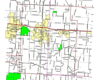
Sni Valley Fire's District Boundaries Map
The boundaries of the Sni Valley Fire Protection District are as follows:
GEOGRAPHIC DESCRIPTION:
East Border: 1 mile East of Z Highway, milepost 33 on I-70
North Border: Truman Road in Jackson County along a line coincident with the center line
West Border: Section line located 100 yards West of Hardsaw Road; milepost 25 on I-70
South Border: Cline Road, the Lafayette - Johnson County line
As of 15 April 1994, the area within the boundary of Sni Valley Fire Protection District formerly served for EMS response by both the City of Odessa and the City of Oak Grove is now the exclusive primary service area of the Sni Valley Fire Protection District, according to the authority granted by the Missouri Bureau of Emergency Medical Services.
LEGAL DESCRIPTION:
Beginning in the Northwest corner of Section 13, T49N-R30W, Jackson County, Missouri, East seven miles to the Northeast corner of Section 13, T49N-R29W, Lafayette County, Missouri, thence South two miles to the Northeast corner of Section 25, T49N-R29W, thence East one mile to the Northeast corner of Section 30, T49N-R28W, thence South eight miles to the Southeast corner of Section 31, T48N-R28W, thence West eight miles to the Southwest corner of Section 36, T48N-R30W, thence North 10 miles to the place of beginning, encompassing 78 Sections (78 square miles).
Sni Valley Fire Historical Photo Page
|
Copyright ©2006 -
Sni Valley Fire Protection District, All Rights Reserved.
|
|

